
■ NovoGov by Novo Solutions · Established 1999
ROAD MAINTENANCE SYSTEM
Track and report on road maintenance, see every segment on the map color-coded by PCI rating, and plan capital improvements from the condition and cost data you already collect.
Trusted by communities in 37 U.S. states, from Rockland, ME to Capitola, CA.
■ Sound familiar
Why the paving plan is so hard to defend
Most road departments know which roads are bad. What they cannot do quickly is show the condition, the work, and the cost of a segment in one place.
NovoGov Road Maintenance System
NovoGov Road Maintenance System is software a public works, street or road department uses to inventory road segments and the assets along them, track the work orders and costs to maintain them, and plan repaving using PASER and PCI condition data on a map. Some governments call this street maintenance software or a pavement management system; the job is the same either way.
It is part of our asset management software and runs on the same platform as our work order software, so the condition of a segment, the work performed on it, and what that work cost all sit on the same record. It is built for small and mid-sized governments, so a small road department can run it without a large IT team.
■ See it running
Watch the demo
This overview demo video shows our road maintenance system software. It includes tracking a road’s pavement conditions, the work orders associated with re-paving it, and the costs the project incurs with NovoGov on the ShareNet Platform.
■ Segments and the map
Every road segment on a map, colored by condition
See road segments, nearby assets, and work orders on a map, with Esri GIS integration. Integrate PASER condition assessment data from a GIS layer so the roads are colored by PCI rating. If you have not defined road segments yet, that is part of the work: identifying all roads and road segments and the assets related to them, including lighting, signage, and stormwater drainage assets such as catch basins, drainage ditches, and culverts.


■ The work and what it cost
Every patch, overlay and reconstruction on the record
All pavement-related work is captured on work orders, from small patch and repair jobs to complete structural improvements, with categories you define such as preventative maintenance, repair, rehab, or structural improvement. Work orders capture the total cost of the work, meaning labor hours, equipment hours, and materials, whether the job is done in-house or outsourced. That is what turns road maintenance management software into a cost record you can report by road. A crew does not need a work order to record its work: the potholes filled on which roads, the hours worked and the equipment used can be logged straight against the road, and routes are handled in the same system too.
■ Planning and the CIP ask
The paving plan, with the evidence attached
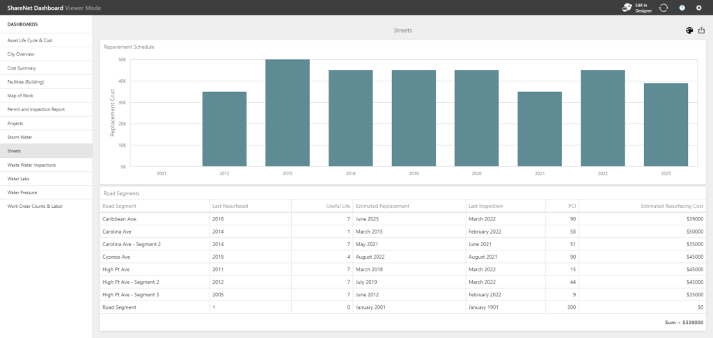
Forecast road capital improvement projects from your condition and cost data, and report the cost of patch and repair work by road so you can decide whether to resurface a segment sooner rather than later. Interactive dashboards show road maintenance cost totals in seconds. Two things come out of that: more informed decisions about road maintenance, and data to justify the budget request.
■ The detail
Road classes, surface types, and every treatment you use
Set up the way your department already classifies its roads, and the way your crews already talk about the work.
■ What switching looks like
Going live without losing your road records
Crews keep working the whole time. Nothing gets turned off until the new system is running.
What our clients say
Steve Blasko, Public Works Director

“What really stood out is that the team at Novo took the time to talk to us, explaining all you can do when you’re utilizing NovoGov. You’re not getting a cookie cutter mobile system when you buy Novo. They’re creating a system tailored to your needs. Their team sat down with every department and built a work order system specifically for them.”

Steven Pilcher, Director of Public Service

“The NovoGov Municipal Software has really helped streamline processes, reduce costs, provide better metrics, and run a more efficient public service department, which in turns creates a better relationship between department staff and the customers served.”

Andy Elder, Street Foreman

“Our Streets team really likes NovoGov, especially because of its mapping capabilities and that I can see all the work orders on my phone while I’m out in the field. Now if a request comes in, I can take snapshots of the work to be done, work in progress, and finalized work, which all help to show proof of the process. The ability to easily document work, locate assets, and manage preventative maintenance of assets on one system is everything to our department. The NovoGov application has saved us a lot of time. Now we have access to documentation in real time vs. lost on a massive worksheet on the office computer.”

Travis Sirrine, Highway Superintendent
“The Board of Selectmen was blown away the first time I showed them what we could now report on. They had no idea how many tasks we handled. Now they have data—charts, work orders, asset histories. It changed the conversation.”
Travis Sirrine, Highway Superintendent

David Seugling, Public Works Director
“Switching to NovoGov has been a game changer for our department. It’s streamlined communication, eliminated paperwork, and made it easy for our field crews to update work orders in real time. The system is incredibly flexible and user-friendly — I’d make the switch to NovoGov again in a heartbeat.”
David Seugling – Public Works Director

■ Taking it to the board
What this looks like in a council packet
■ Built for government
What your procurement team will ask
■ Questions we get
Road Maintenance Software FAQ
■ Next step
Request a demo
A working session on your own road network, not a slide deck. We will show you a segment on the map with its PCI rating, the work orders and costs attached to it, and what the repaving forecast looks like when the council asks.